North Canterbury Fold and Thrust Belt, New Zealand
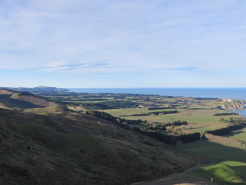
The North Canterbury fold and thrust belt (NCFTB) of New Zealand is a region of young, actively growing, basement-involved fault-propagation folds. The fold belt is developing as part of a complex plate boundary transition region in the northeastern part of New Zealand's South Island. Fold growth has uplifted marine terraces along the coast, which act as markers of deformation over time. The region, therefore, is a good place to investigate a number of questions including the kinematics of fault-propagation folding, the relationship between structural geology and geomorphology, and the role of the NCFTB in accommodating plate boundary deformation. This region was the setting for my Ph.D. dissertation research, supervised by Don Fisher at Penn State. My work here has involved dating marine terraces, modeling fold kinematics and fault geometry, using marine terraces and the patterns of uplift rates that they record to constrain fold kinematic models and calculate fault slip rates, and constructing a balanced cross section across the NCFTB to estimate the total shortening that it has accommodated. I have made substantial use of my InvertTrishear program in my New Zealand work, and the problems that I have encountered there have influenced development of the program.
Publications:
- Oakley, D.O.S., Fisher D.M., Gardner, T.W., and Stewart, M.K., 2018. Uplift rates of marine terraces as a constraint on fault-propagation fold kinematics: Examples from the Hawkswood and Kate anticlines, North Canterbury, New Zealand. Tectonophysics 724-725, 195-219.
- VanderLeest, R.A., Fisher, D.M., Oakley, D.O.S., and Gardner, T.W., 2017. Growth and Seismic Hazard of the Montserrat Anticline in the North Canterbury Fold and Thrust Belt, South Island, New Zealand. Journal of Structural Geology 101, 1-14.
- Oakley D.O.S., Kaufman, D.S., Gardner, T.W., Fisher, D.M., and VanderLeest, R.A., 2017. Quaternary marine terrace chronology, North Canterbury, New Zealand using amino acid racemization and infrared stimulated luminescence. Quaternary Research 87, 151-167.
Inverse Modeling of Fault-Related Folds
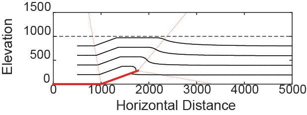
Kinematic models of fault-related folding are a valuable tool in structural geology and are widely used to predict subsurface fold structure and reconstruct structural histories. These methods find applications in seismic hazard assessment, resource exploration, and tectonic studies. The models produced by typical forward modeling workflows are, however, not unique. Data inversion methods such as Markov chain Monte Carlo simulations provide the means to both find the model that best fits a given dataset and calculate uncertainty in model parameters. Rather than providing a single result, such stochastic methods can provide an ensemble of possible models. Although widely used in fields such as geophysics, data inversion methodologies have not seen widespread use in structural geology. In this work, I aim to develop, test, and apply tools to facilite data inversion and the use of stochastic methods in modeling fault-related folds. A primary aspect of this research has been the development of the InvertTrishear program for inverse modeling of trishear fault-propagation folds using Markov chain Monte Carlo methods.
In my postdoctoral research at the University of Stavanger, I worked on two inverse modeling projects. In one, I applied the Ensemble Kalman Filter to restoration of complex, three-dimensional structural models. In the other, I applied data inversion to geomechanical boundary element models as an alternative to kinematic methods. A paper on the first project has now been published.
Publications:
- Oakley D.O.S., Cardozo, N., Vazquez, A.A., and Røe, P., 2023. Structural geologic modeling and restoration using ensemble Kalman inversion. Journal of Structural Geology 171, 104868.
- Cardozo, N.F. and Oakley, D., 2019. Inverse modeling for possible rather than unique solutions. Journal of Structural Geology 125, 285-295.
- Oakley D.O.S. and Fisher, D.M., 2015. Inverse trishear modeling of bedding dip data using Markov chain Monte Carlo methods. Journal of Structural Geology 80, 157-172.
Subduction Interface Processes and Earthquake b-values
This project aims to investigate the role of fault-healing by silica redistribution in controlling earthquake dynamics at subduction zones. My role in the project has primarily involved the analysis of earthquake frequency-magnitude relationships (b-values) at different subduction margins and investigations of the relationship between b-value and temperature.
An important part of this project is the development of the Mefisto program for modeling subduction zone behavior, which is led by John Hooker at the University of the Incarnate Word. The program is available for download here: Mefisto
Publications:
- Fisher, D.M., Hooker, J.N., and Oakley, D.O.S., 2019. Numerical models for slip on the Subduction interface motivated by field observations. Lithosphere 11(3), 322-332.
Geophysical Imaging of the Critical Zone
This was a postdoc project, supervised by Andrew Nyblade and Sue Brantley at Penn State. The primary goal of my work was to use ambient noise seismology to look for changes in seismic velocity in the shallow subsurface at the Susquehanna Shale Hills Critical Zone observatory in Pennsylvania. This method uses the small vibrations caused by cars, wind, or other processes — rather than seismic waves generated by earthquakes or deliberate human-made sources — to measure seismic velocities in the Earth. While we originally aimed to observe the movement of water in the critical zone over time, we found that the strongest time-varying signals in the ambient noise related to temperature changes, with water playing only a secondary role. We also conducted electrical resistivity surveys at Shale Hills, which more clearly revealed water flow paths and changes over time and provided evidence of the role of geologic structure in controlling electrical anisotropy.
The ambient noise project complemented traditional seismic refraction surveys, and I assisted with interpreting that data as well. Those studies revealed the depths of rock weathering and porosity generation at Shale Hills and showed that the "bowtie" pattern of weathering expected from previous studies does not occur at Shale Hills.
Publications:
- Yoxtheimer, D.A., Oakley, D.O.S., Nyblade, A.A., Mount, G., 2023. Geo-electrical anisotropy corrections derived from square array data to improve Earth resistivity models of the Shale Hills’ critical zone. Journal of Applied Geophysics 215, 105113.
- Hodges, C., Regan, J.M., Forsythe, B., Oakley, D., Kaye, J., and Brantley, S.L., 2023. Using fixed-potential electrodes to quantify iron and manganese redox cycling in upland soils. Biogeochemistry 162, 25-42.
- Ma, L., Oakley, D., Nyblade, A., Moon, S., Accardo, N., Wang, W., Gu, X., Brubaker, K., Mount, G.J., Forsythe, B., Carr, B.J., and Brantley, S.L., 2021. Seismic image of a shale landscape under compression shows limited influence of topography-induced fracturing. Geophysical Research Letters 48, e2021GL093372.
- Oakley, D.O.S., Forsythe, B., Gu, X., Nyblade, A.A., and Brantley, S.L., 2021. Seismic ambient noise analyses reveal changing temperature and water signals to 10s of meters depth in the critical zone. Journal of Geophysical Research: Earth Surface.
- Gu, X., Mavko, G., Ma, L., Oakley, D., Accardo, N., Carr, B.J., Nyblade, A.A., and Brantley, S.L., 2020. Seismic refraction tracks porosity generation and possible CO2 production at depth under a headwater catchment. Proceedings of the National Academy of Sciences, 117:32, 18991-18997.
Marcellus Shale
The Marcellus shale of the Appalachian Basin is a major gas-producing unit in Pennsylvania and surrounding states. Hydraulic fracturing ("fracking") has allowed this valuable resource to be exploited but has also become a source of envirnomental concern. I have contributed structural modeling and analysis to studies of aquifer contamination near shale gas wells. I have also worked to map the depth and thickness of the Marcellus and Utica shales and the depth to basement in Pennsylvania.
Publications:
- Hammond, P.A., Wen, T., Woda, J., and Oakley, D., 2024. Pathways and environmental impacts of methane migration: case studies in the Marcellus Shale, USA. Geofluids, 9290873.
- Woda, J., Wen, T., Oakley, D., Yoxtheimer, D., Engelder, T., Castro, M.C., and Brantley, S.L., 2018. Detecting and explaining why aquifers occasionally become degraded near hydraulically fractured shale gas wells. Proceedings of the National Academy of Sciences, 201809013.
Shimanto Belt, Japan
In this project, we dated motion on faults in the Shimanto Belt accretionary complex of Shikoku, Southwest Japan, using K-Ar dating.
Publications:
- Fisher, D.M., Tonai, S., Hashimoto, Y., Tomioka, N., and Oakley D., 2019. K-Ar dating of fossil seismogenic thrusts in the Shimanto accretionary complex, southwest Japan. Tectonics 38:11, 3866-3880.
Automatic Recognition of Geologic Structures
In this project, I used machine learning methods to automatically identify geologic structures on geological maps. This was work I completed while a postdoc in France with Christelle Loiselet of the Bureau de Recherches Géologiques et Minières (BRGM) and Jean-Paul Callot of the Université de Pau et Pays de l'Adour.
- Oakley, D., Loiselet, C., Coowar, T., Labbe, V., and Callot, J.-P., 2025. GEOMAPLEARN 1.2: detecting structures from geological maps with machine learning – the case of geological folds. Geoscientific Model Development 18, 939-960.
Landscape Evolution Modeling in the European Alps
In this project, I am using landscape evolution models to understand the tectonic history of the European Alps. Building on my previous work with data inversion, I am attempting to apply data inversion methods to this problem, so that I can fit landscape evolution models to features of the real-world landscape. This was my previous postdoctoral research at the University of Glasgow with Paul Eizenhöfer, and a paper is now in preparation.